POI Editor
How To : Create Your Own Points Of Interest
By Barto in How To. July 2, 2008
How To

General
New users to the site might want to read this guide on how to create your own Points of Interest from scratch. Creating a POI with POI Editor is fairly straight forward so lets get stuck in and create our own.
First, open a new browser window and go to POIEditor.com. Click Add Point, a menu should appear that allows us to enter a name and its lat/long coordinates. If you know the coordinates just enter them here along with a name for the location and click the 'Save Point' button. You can enter coords in either decimal (e.g. 53.44941, -2.76163), Degrees / Minutes / Seconds (e.g. N 53? 26' 57, W 2? 45' 41) or Degrees / Decimal minutes ( e.g. N 53? 26.9646' W 2? 45.6978' )
If you don't know the coordinates of the point you want to add there are a couple of options. The first, and easiest, way is to use the geocoding function - just enter the address or postcode in the Address input box and click Look up, after a couple of seconds you should get the coordinates for your location and a marker on the map.
Alternatively, clicking anywhere on the map will create a marker with its latitude and longitude automatically shown. Initially the map shows a world view but by using the buttons on the map we can pan and zoom to narrow the view down easily - this should be familiar to anyone that's used Google Maps before. Again, clicking anywhere on the zoomed map will produce a marker that we can drag around to pin-point the location we're looking for. As we drag the marker you can see the lat/long coordinates change in the boxes to the right.
It doesn't take long to locate the UK and then Leeds, where I live, and with a few zooms later I think I've found the location of a local pub. I'll move my marker here (by clicking on the map) and the lat and long positions update in the boxes to the right. Now I need to name my point, I'll pick 'The Pub' and click 'Save Point' to save this as one of my POIs.
But before I save, I'm not 100% sure that my marker is in the exact spot. If I click 'Satellite' on the map I get an aerial photo view which lets me zoom down to 50ft. I can now see the pub and that marker was a little out, not enough to make much difference when driving by, but I'll move it to right on the pub doors anyway. Clicking the 'Save Point' button, removes the 'add point' box and displays my entry in a list. There's only one so far so lets add some more.
I'll now use the same method to add another place. clicking 'Add Point', zooming out a little, positioning the marker and clicking 'Save Point'. I now have two points in my list and selecting either one will move the map to its location and allows me to drag the marker to further refine the position or change it completely. Clicking the '-' button lets me delete a point from the list if I'm not happy with it.
A few minutes later and I've created a little list of local spots. Clicking 'Save POI File' brings up a dialog box that lets me enter a name for my POI and select the format. There are a few supported POI formats, I'm selecting TomTom OV2 as that's what my Sat Nav is. It's now just a question of copying the OV2 file to my TomTom.
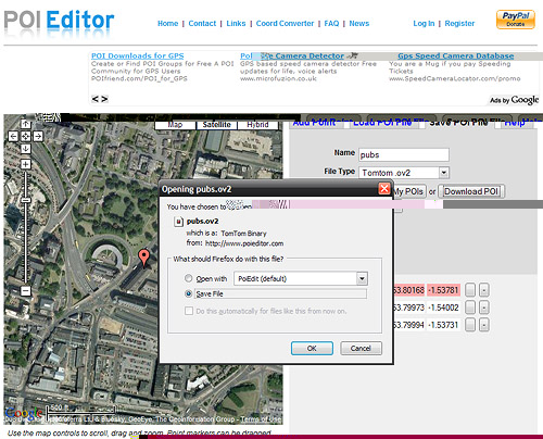
If at a later date I wanted to add more places to my POI I could use the 'Load POI' option to load my file and then add more points as needed. If I had two separate POI files I could select the merge option within the 'Load POI' page to combine them into one file or convert between formats for different GPS devices.
Related Articles : How To Install POIs On TomTom, Recent Work